
Garnet Back Country Byway
Montana. Back country byway.
Details
- Where
- MT. No street address stated. Directions
- When
- Visitor center open daily from 10 a.m. to 4:30 p.m., late May through September, depending on weather.
- Season
- Visitor center open from late May through September, depending on weather.
- Getting there
- From State Highway 200, about 30 miles east of Missoula, turn south between mile markers 22 and 23. From Interstate 90, take either the Drummond or Bearmouth exit and follow old U.S. 10 to Bear Gulch Road.
- Fees
- No Fee.
- Access
- The route is steep, narrow, and rough; it is not recommended for trailers or RVs. Winter access from either direction is only by snowmobile, snow shoes, or cross-country skis.
- Phone
- 406-329-3914
- Managed by
- Missoula Field Office.
A steel-and-timber kiosk stands in a large pull-out on the south side of Garnet Range Road, a tenth of a mile off State Highway 200 and about 30 miles east of Missoula. It holds a map, a short course in geology, and a warning that no services are available on or near the byway. The inscription opens on the sounds of the old country: “Once, the Garnet Mountains echoed with the blasts of dynamite, the clatter of hooves on steep, narrow roads, and the shouts of men out to find fortune.”
The Bureau of Land Management’s Missoula Field Office manages the route. It gives the Garnet Back Country Byway as 12 miles long, climbing 2,000 feet through the Garnet Range to Garnet Ghost Town. The kiosk counts differently. By its reckoning, a traveler who follows the road to Garnet and continues over the summit covers 26 miles. Doug Stevens, writing in Distinctly Montana in 2020, drove those 26 miles as a loop from Highway 200 down to Bearmouth and Interstate 90. Back Country Byways, a kiosk panel explains, are a national effort to help people explore the less-traveled areas of public lands. The panel calls this one “remote and lightly visited, even by Western Montana standards.”
Sand Park and the Mystery Camp
Stevens recommends starting from the north, where the road is wider and better maintained. About 5 miles in is Sand Park Cemetery. It has five marked graves, presumably of miners from Coloma, and many unmarked ones. Just past it, a road to the left leads to Coloma, often called the “Mystery Camp” because so little is known about it. More than 20 structures remain there, few of them intact, on a slope above the Blackfoot River Valley with the Swan Range and the Scapegoat Mountains beyond. A few miles farther on is a scenic overlook with a picnic table. From there the view widens to the Mission Mountains and the Rattlesnake above Missoula, and Stevens calls it an excellent place for a sunrise.
The range under the road took shape between 75 and 70 million years ago. Great thrust faults then carried the Sapphire Block eastward from the top of the Idaho batholith, and the Garnet Range forms the block’s northern edge. Granite magma rose beneath it. Where the granite cooled in fractures of sedimentary rock, quartz and gold separated into veins, and as those rocks weathered, gold flakes washed into the streams. Where the magma met limestone, the two reacted to form a rock called skarn, made mostly of garnet crystals. The kiosk names the skarn as the range’s namesake.
Timber came out of these hills alongside the ore. Loggers cut beams for mine shafts, ties for the railroad, and fuel for the trains that hauled ore. The University of Montana’s Lubrecht Experimental Forest, established in 1937, is one of the byway’s partners. Mining and logging still go on here on private and public land, and the BLM warns of heavy truck traffic on some roads.
Main Street, Garnet
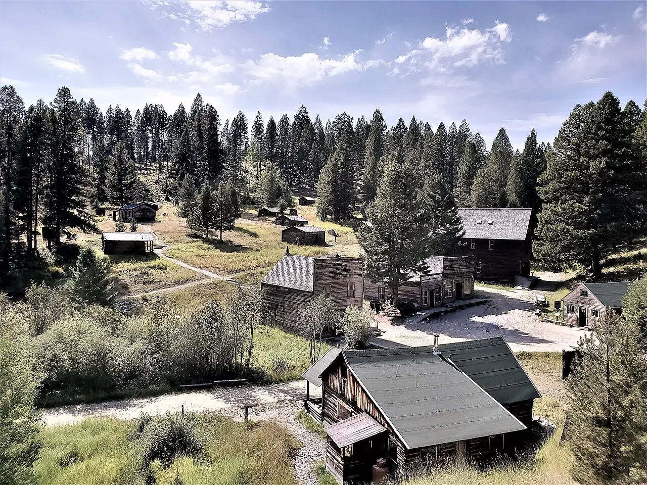
From the overlook the road descends into Garnet. The BLM counts 30 buildings there that, after extensive preservation work, look much as they did in 1895. Stevens put the number maintained for the public at about two dozen. In the words of the Montana National Register Sign Program, the remaining commercial false-fronts and log dwellings “reflect Garnet’s life span from 1895 to 1948.”
Kelly’s Saloon, Davey’s Mercantile, and the Wells Hotel stand on Main Street, and the Adams House is on the walking tour. The visitor center occupies the old Ole’s Tavern, near the general store, and the Bill Hubner cabin serves as the staff office. The center is open daily from late May through September, weather permitting, and has information on nineteenth-century life in the camp. The BLM’s history gives the pronunciation of the town’s name: like “Darn-it.”
Most of Garnet is publicly owned. One building is private, and private land is common in the surrounding hills. Digging, metal detectors, camping, open fires, and the removal of artifacts are prohibited. Stevens found no fences or barriers and photographed the stars over the rooftops after dark.
From December through April the BLM rents two cabins in town, reserved in advance through the Missoula Field Office. In winter the town can be reached from either direction only by snowmobile, snowshoe, or cross-country ski. The Back Country Byway signs then mark 116 miles of trail for snowmobiling, skiing, and dog sledding.
Down Bear Gulch to Beartown
The road divides at Garnet. First Chance Gulch Road is steep, narrow, and rocky, with tight switchbacks. Cave Gulch Road, the old stage route, has a much better grade. The BLM calls the Bear Gulch side steep, narrow, and rough, and does not recommend it for trailers or RVs. The kiosk adds buses and motorhomes to that list and warns of barbed wire, mine shafts, and cattle guards off the road.
Both routes reach Beartown at the head of Bear Gulch. At its peak Beartown had 17 saloons, a brewery, and, in Stevens’s phrase, “a reputation to match.” Nothing remains now but a couple of BLM plaques, one of them about a famous miner named “Shorty” and the story of his arm. Below Beartown the road improves and leaves the gulch at Bearmouth on the interstate. Coming the other way, travelers take the Drummond or Bearmouth exit, follow old U.S. 10 to Bear Gulch Road, and climb 11 signed miles to Garnet.
Placer gold and a ten-stamp mill
The district began at Beartown. The BLM’s history records a strike in the early 1860s where Bear Creek meets the Clark Fork River, then another in 1865 up Bear Gulch, which became Bear Town. Prospectors worked up the creeks with pans, rockers, and sluice boxes. A 32-ounce nugget found on Bilk Creek brought more of them into the mountains.
Placer mining grew less profitable by the 1870s, and by the 1880s Beartown was in severe decline. Some miners stayed on, among them Samuel Ritchey, who recognized that the range was rich in gold-bearing quartz. For about thirty years, the National Register text says, the mother lode stayed out of reach. There was no road for heavy equipment and too little water for placer work.
Silver mines elsewhere drew men away until the repeal of the Sherman Silver Purchase Act emptied the silver camps and turned miners back toward gold. The Garnet Preservation Association dates the repeal to 1893; the BLM dates it to 1895. Between 1890 and 1895, 40 lode claims were filed in the First Chance Mining District, several of them held by Drs. Armistead Mitchell and Charles Mussigbrod. The BLM and the National Register text say the two men built a ten-stamp mill in First Chance Gulch in 1895. The Preservation Association credits Mitchell alone.
A town called Mitchell grew up around the mill. Road building began the same year and eventually linked the camp with Bearmouth and the Northern Pacific Railroad, which had been completed in 1883. The kiosk dates the finished Coloma–Garnet–Bearmouth Road to 1896. By 1897, the Preservation Association says, Mitchell had become Garnet.
Soon after the mill went up, Ritchey struck a rich vein in his Nancy Hanks mine just west of it; the National Register text gives the year as 1896. By January 1898 nearly 1,000 people lived in Garnet. The town had four stores, three livery stables, two barber shops, a union hall, a butcher shop, a candy shop, a doctor’s office, an assay office, 13 saloons, and a school with 41 students. The BLM adds a drugstore and counts seven hotels, while the Preservation Association counts four. About twenty mines operated, and the Fairview quartz lode mine opened in 1898. Builders worked fast and without a plan. Most buildings stood on existing or future mining claims, and many had no foundations.
Garnet drew more families than earlier camps had. Residents held dances, hayrides, quilting bees, and picnics in summer, and sleigh rides and sledding parties in winter. The Miners Union Hall, completed in June 1898, held a community dance every Saturday night, and its one large room and small stage often “was scarcely large enough for the crowd.” Independent mine owners kept cordial relations with the miners union, unlike company towns such as Butte and Philipsburg, and the Garnet Mining News called the town a “poor man’s paradise.” A photograph from 1899 shows the mail stage in front of the post office with Lewis driving, Judson’s Store at the right, and Long Walt, who made cigars, standing at the corner.
Fire, a second boom, and the auction
The boom did not last. By 1900 many of the veins had disappeared, and deeper shafts made gold costly to recover. Many owners, Ritchey among them, leased their mines to others; he had taken out an estimated $300,000 in gold. By 1905 many mines were abandoned and about 150 people remained. In 1912 a fire in the business district destroyed many commercial buildings, and the kiosk marks that year as the end of the hard-rock era. The BLM estimates the town’s total yield by 1917 at between $950,000 and $1,400,000; the Preservation Association gives $950,000.
When the United States entered World War I, many of the remaining residents left for defense jobs. They abandoned their cabins with the furnishings inside, “as though residents were merely vacationing.” Frank A. Davey still ran his store, and the hotel stood intact.
In 1934 President Roosevelt raised the price of gold from $16 an ounce, to $35 by the BLM’s figure and $32 by the Preservation Association’s. Miners moved into the empty cabins and reworked the old mines and dumps. By 1936 about 250 people lived in Garnet, and several new log cabins went up. World War II drew them away again. Wartime limits on dynamite made mining nearly impossible, and the post office closed for the last time in 1942.
Davey stayed. He owned the general store, the hotel, and the stage line, and he had believed in Garnet’s future through boom and bust. He died in 1947. In 1948 his holdings were sold and the store’s contents auctioned, which the National Register text marks as the beginning of Garnet as a ghost town. Souvenir hunters followed and took doors, stained glass, wallpaper, and woodwork, including the oak banister and spindles of the Wells Hotel stairway. The BLM and the Garnet Preservation Association later secured title to the properties, and since 1972 the BLM has stabilized many of the buildings.
Sharon Seadin’s grandparents raised six children in Garnet, and her father worked its mines. In 2021 she wrote: “I try to go back there every summer to pay respect to my ancestors, many of them had their ashes spread in Garnet.”
Notable Events
- 1860sIn the early 1860s a strike on Bear Creek at its confluence with the Clark Fork River brought many prospectors to the area; another strike occurred in 1865, this time up Bear Gulch, which became Bear Town. southwestmt.com
- 1865The 1865 gold strike on Bear Creek in the Garnet Range drew prospectors from far and wide. historicmt.org
- 1880sBeartown is where it all started with a gold strike in 1865, but by the 1880s Beartown was in severe decline; at its peak it had 17 saloons, a brewery, and a reputation to match. distinctlymontana.com
- 1890sOne thousand people called Garnet home in the 1890s as they scoured the mountains for gold; the town was largely abandoned 20 years later when the gold ran out. blm.gov
- 1890Between 1890 and 1895, 40 lode claims were filed in the First Chance Mining District, and several claims were held by Drs. Armistead Mitchell and Charles Mussigbrod. southwestmt.com
- 1895At the head of First Chance Gulch in 1895, Dr. Armistead Mitchell erected a stamp mill to crush local ore, and the town grew around it. garnetghosttown.org
- 1896When Samuel Ritchey struck a rich vein of gold at his Nancy Hanks mine, just west of the mill in 1896, Garnet sprang to life. historicmt.org
- 1897The town, originally named Mitchell, became known as Garnet in 1897. garnetghosttown.org
- 1898By January 1898 nearly 1,000 people resided in Garnet. garnetghosttown.org
- 1900By 1900 many of the veins had disappeared and many mine owners, including Ritchey, who had extracted an estimated $300,000 worth of gold, leased their mines to others. southwestmt.com
- 1905By 1905 many of the mines were abandoned and the town's population had shrunk to about 150 residents. southwestmt.com
- 1912A fire in the town's business district in 1912 destroyed many commercial buildings. garnetghosttown.org
- 1917It is estimated that between $950,000 and $1,400,000 in gold was extracted from all the mines in Garnet by 1917. southwestmt.com
- 1934In 1934 when President Roosevelt raised gold prices from $16 to $32 an ounce, Garnet revived; a new wave of miners moved into abandoned cabins until World War II drew the population away again. garnetghosttown.org
- 1942The post office closed for the last time in 1942. southwestmt.com
- 1947After his death in 1947, his general store's contents were auctioned off. southwestmt.com
- 1948In 1948 an auction was held with items from the Davey store; souvenir hunters soon stripped the town of loose items, doors, woodwork, wallpaper, and even the hotel stairway. garnetghosttown.org
- 1972Since 1972, the Bureau of Land Management has stabilized many of the town's buildings and vigilantly oversees its historic resources. historicmt.org
People
- Dr. Armistead Mitchell, erected the stamp mill around which the town, originally named Mitchell, grew (1895).
- F. A. Davey, ran the store and stayed on after the town emptied.
- Sam Ritchey, hit a rich vein of ore in his Nancy Hanks mine just west of the town, starting the boom.
- Dr. Charles Mussigbrod, Partner of Dr. Armistead Mitchell; with him he developed the stamp mill at First Chance Gulch around which the town grew (1895).
- Frank A. Davey, Owner of the general store, hotel and stage line and Garnet's most prominent resident, who steadfastly believed in the town's future through boom and bust (died 1947; holdings sold 1948).
- Samuel Ritchey, Miner who persevered when placer mining became less profitable, recognizing that the area was rich with gold-bearing quartz; his Nancy Hanks mine started the boom (by the 1870s).