
Coulee Corridor Scenic Byway
Grand Coulee, Adams, Douglas, Franklin, Grant, Lincoln, and Okanogan County, Washington. National Scenic Byway.
Details

- Where
- Grand Coulee, Adams, Douglas, Franklin, Grant, Lincoln, and Okanogan County, WA. No street address stated. Directions
- Getting there
- 150 miles; allow 3.5 hours to drive the byway.
- Fees
- None.
- Access
- Look for the distinctive Coulee Corridor signs along the right hand sides of the roads; community kiosks installed by the Consortium at Grand Coulee, Coulee City, Soap Lake, Warden, and Othello.
- Website
- fhwaapps.fhwa.dot.gov
- Managed by
- Coulee Corridor Consortium, a 501(c)(3) non-profit organization.
The signs stand on the right-hand side of the road and read Coulee Corridor. A driver following them north from Othello on State Highway 17 will also pass, somewhere between Moses Lake and the Grant-Adams county line, smaller signs set at the edges of fields in crop: alfalfa, grass, grain corn, silage corn, wheat. Fourteen crop signs were made in 2020, and nine went up along SR 17 in 2021. The Coulee Corridor Consortium counted five still standing in 2025 and asks travelers to “see if you can find them.”
The byway runs about 150 miles between Othello and Omak on SR 17, US 2 and SR 155, through Adams, Douglas, Franklin, Grant, Lincoln and Okanogan counties. The federal byways listing allows 3.5 hours for the drive and lists no fees. Loops and spurs branch off to Connell, Warden, Ephrata, Wilson Creek, Almira, Hartline, Palouse Falls, Kahlotus, Washtucna and Lyons Ferry. Counting these, the Consortium names 22 towns. Traveler services are grouped in nine towns along the main route, with open country between them. In December 2019 the Consortium put up interpretive kiosks in Grand Coulee, Coulee City, Soap Lake, Warden and Othello, each with content prepared by its own town. The federal listing adds that the corridor is often chosen for car commercials.
Cranes and pothole lakes below Soap Lake
The southern end is irrigated desert. Much of the area gets less than 9 inches of rain a year. Irrigation water from Grand Coulee Dam arrived in the early 1950s, and Grant County now grows more potatoes than any other county in the nation, along with row crops, orchards, vineyards, dairies and livestock. In Othello, the Old Hotel, built in 1912, now houses an art gallery. Historic murals are painted on walls in Connell, Warden and Moses Lake.
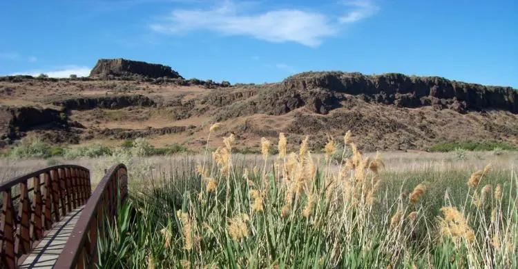
Columbia National Wildlife Refuge lies on a loop and spur off the byway near Othello. A 22-mile drive crosses some of the refuge’s most dramatic scabland. People come to watch birds, fish, canoe, hike and hunt, and the National Scenic Byway Foundation lists waterfowl, coyotes, lakes and marshes among what they find. In March the Othello Sandhill Crane Festival marks the spring migration, and most of its tours go to the refuge. The 2018 festival, held March 23 to 25, took the theme “H20 & Birds on the Go.” Its co-chair, Kurt Braunwart, said that year, “without natural water or irrigation water, many of the birds and wildlife would not be here.” Audubon Washington has published a Great Washington State Birding Trail map for the corridor.
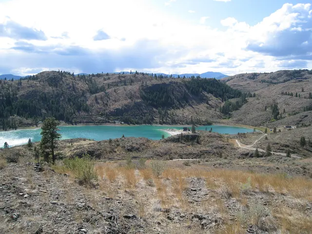
At Potholes State Park, depressions carved by the floods filled with water after O’Sullivan Dam was built. The result is hundreds of tiny islands set among “pothole” lakes. Moses Lake lies about 26 miles north of Othello, and Soap Lake 23 miles beyond it. At Soap Lake, people come for the mud, the salty water, the sandy beaches and the warm weather, and the Consortium notes how few fishermen work the lake. An annual Pow Wow has been revived there in recent years, and in some years hydroplane races are allowed. Ephrata, on a loop just off the route, is the Grant County seat; its courthouse was finished in 1918.
Up the Grand Coulee
North of Soap Lake the road enters the Lower Grand Coulee. Two short hikes there, the Lake Lenore Caves and the Lakeside Discovery Trail, cross the basalt and the scabland. The caves are a pair of lava tubes above Lake Lenore that visitors can walk into and look out from. The Consortium invites them to imagine what Native Americans saw from the same openings. Other trails follow the edges of Park Lake and Deep Lake. The Stage Coach Trail, also called the Caribou Trail, climbs the ridge above Deep Lake along an old route across the coulee.
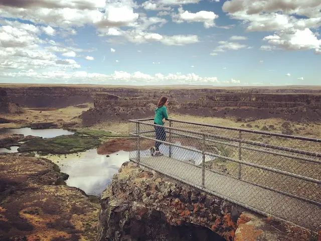
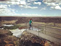
South of Coulee City stands Dry Falls, a former waterfall that is now a bare cliff 400 feet high and 3.5 miles wide. The National Scenic Byway Foundation describes the falls as four times the size of Niagara. Sun Lakes-Dry Falls State Park, at its foot, has camping, access to a freshwater lake and a golf course.
In the upper coulee the route follows Banks Lake to Steamboat Rock State Park. The park covers 3,522 acres and has 50,000 feet of shoreline, a sandy swimming area and boat launches. Trails lead up Steamboat Rock and into Northrup Canyon. Before the lake was filled, Steamboat Rock rose about 1,400 feet above a ranch. In the early 1900s George Baldwin’s family ran the Coulee Live Stock Company there, beside Devils Lake. According to a sketch by Birdie Hensley in the Consortium’s newsletter, the coulee walls made the growing season there often 30 days earlier than on the uplands. The ranch had an irrigated orchard, a dairy barn with 50 milk cows, an ice house supplied from Devils Lake, and a Jersey herd whose cream was shipped to Seattle and Spokane. In 1912 a fire burned the ranch dwellings, and the family moved toward the mouth of Northrup Canyon. That same year, a party of forty members of the European Geographical Association and 30 American professors left the train at Almira and drove down the old stage road to the Grand Coulee. They stopped for lunch at the Baldwin ranch, and everything served had been grown there. Baldwin sold out in 1917. Under the Bar Eleven brand the place raised hogs and later sheep. The Bureau of Reclamation bought it in 1942 for Banks Lake, and most of it lies under water today. The Coulee Pioneer Museum in Electric City keeps more of this history and opens by appointment.
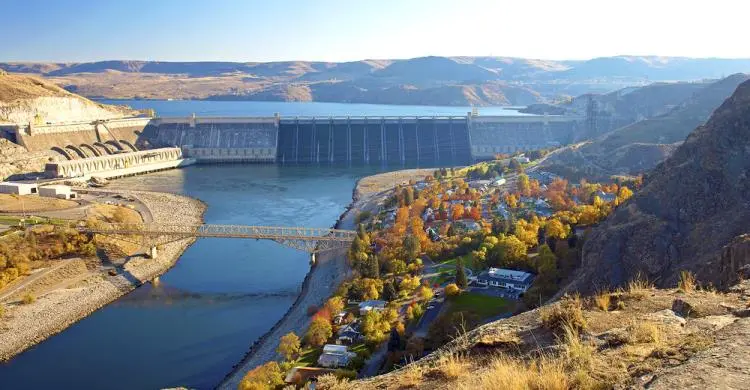
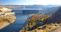
Grand Coulee Dam was built between 1933 and 1942. Scenic Washington calls it the largest concrete structure ever built. The National Scenic Byway Foundation calls it the largest in the United States and the world’s third-largest producer of electricity. Free 50-minute guided tours are offered first come, first served. From Memorial Day weekend through September, a laser light show plays across the face of the dam every night. The dam anchors the Columbia Basin Irrigation Project, which supplies water for more than 75 kinds of crops.
Through Colville country to Omak
In February 2025 the City of Coulee Dam put a trailblazer sign on the bridge over the Columbia River, where the road enters Okanogan County. The Consortium counted it a major accomplishment of that year. Beyond the bridge is the Colville Indian Reservation. It is home to the Moses/Columbia, Wenatchee, Okanogan, Entiat-Chelan, Methow, Nez Perce, Palus, Nespelem, Colville, San Poil and Lake peoples, and to the dam itself. The Colville Tribal Museum in Coulee Dam has murals of the Nez Perce trail and of Kettle Falls before the dam, along with videos on the area’s geology and history. Chief Joseph and Chief Moses are buried at Nespelem.
From the dam the byway runs about 52 miles to Omak. St. Mary’s Mission, established in 1886, stands near Omak. The town has about 4,650 people and is the largest in Okanogan County. It has held the Stampede Rodeo, Suicide Race and Indian Encampment on the second weekend of August since 1933.
Bretz, Pardee and Lake Missoula
French Canadian fur trappers, among the earliest European explorers here, gave the central canyon its name. Coulee is French for a dry riverbed or canyon. The Grand Coulee runs 50 miles, nearly a thousand feet deep and two to five miles wide, between sheer basalt walls. The Consortium’s history page is written in the byway’s own voice, and it says: “although my French name means dry canyon, my dominant resource has been water.” The page dates the floods to between about 17,000 and about 11,000 years ago. Scenic Washington says they came several times until around 13,000 years ago.
Geologists at first read the plateau’s coulees, buttes, dry cataracts, giant ripple marks and gravel bars as the work of ordinary processes over long time. In 1923 J Harlen Bretz published the first of a series of papers arguing that the scablands and Dry Falls had been cut by huge floods. His peers doubted him, and a long dispute followed. Bretz could not say where the water had come from. As early as 1910, Joseph T. Pardee had described an ice-dammed lake in northwestern Montana, Glacial Lake Missoula. In 1940 Pardee reported ripple marks 50 feet high and 200 to 500 feet apart on the old lake floor. They showed that the lake had emptied suddenly to the west. By the 1960s geologists had accepted the floods.
According to the Ice Age Floods Institute account on the Consortium’s site, the lake held more than 500 cubic miles of water, as much as Lake Erie and Lake Ontario combined. It may have drained in as little as two or three days, at a peak flow ten times that of all the world’s rivers together. The ice dam formed and failed scores of times. The floods built gravel bars 400 feet tall.
The floods left more than landforms. In the spring of 2015, Luke Tonnemaker was plowing an alfalfa field on the north flank of the Frenchman Hills, west of Othello near the SR 262 spur, when bones turned up in the tilled ground. Volunteers excavated over the next couple of years and identified a skull without tusks, along with ribs, leg bones and teeth, all from a single mammoth. Volcanic ash and luminescence dates from the layers beneath the bones gave ages of about 16,000 to 20,000 years. The Consortium’s newsletter reports the site lies at the shoreline of the highest Missoula flood in the region, and that how the animal came to rest there is unknown.
From a 1997 grant to a party in 2005
A Moses Lake planning document records that the corridor, including SR 17 through Moses Lake, was designated a Washington State Scenic Byway in 1967. In 1997 residents used a grant from the Federal Highway Administration’s National Scenic Byways Program to write a Corridor Management Plan. From that work came the Coulee Corridor Consortium, first a 501(c)(6) corporation and later a 501(c)(3). Its members helped publish a Geologic Guide to the Coulee Corridor, People and Places of the Coulee Corridor, and Top 26 Trails in Grant County.
In September 2005, U.S. Transportation Secretary Norman Mineta named the corridor a national scenic byway, one of 45 roads designated that year. The Consortium’s president, Tim Alling, was in Washington, D.C., for the announcement. “Oh, wow,” said the secretary, Rita Tuller. “It really is incredible.” She added, “Tim Alling has been the driver of it within our community.” Bill Kelley, a professor at Eastern Washington University and a Consortium supporter, said, “One thing we’re going to do is have a big party and celebrate.”
Alling was still chairman in 2013. That year he asked Electric City, Grand Coulee and Coulee Dam for $1,200 each toward advertising and an Ice Age Floods driving map, on a projected budget of $28,650. Mark Amara now chairs the group. Signs for Othello’s streets and its two new roundabouts were delivered in 2026, and installing them is up to the city.
Notable Events
- 1923J Harlen Bretz published the first of a series of papers proposing that the channeled scablands, Dry Falls, and other features were formed by huge powerful floods during the Ice Age. couleecorridor.com
- 1933Grand Coulee Dam, a corridor anchor, was built during the depression-era between 1933 and 1942. scenicwa.com
- 1940Joseph T. Pardee reported giant ripple marks on the floor of Glacial Lake Missoula, confirming the lake had suddenly emptied and unleashed the erosive floods that shaped the Columbia Plateau. couleecorridor.com
- 1950sWith the introduction of irrigation water from Grand Coulee Dam, the desert of the Columbia Basin was turned into an oasis. couleecorridor.com
- 1967The Coulee Corridor, including SR 17 through Moses Lake, was designated a Washington State Scenic Byway. cityofml.com
- 1997A Corridor Management Plan was adopted describing the byway's intrinsic qualities, their management and interpretation, and marketing strategies. cityofml.com
- 2005National Scenic Byway recognition, one purpose of the Corridor Management Plan, was achieved in 2005. cityofml.com
- The Ice Age floods carved out the pathways later followed by humans through the corridor. couleecorridor.com
People
- Bill Kelley, Eastern Washington University professor and Coulee Corridor Consortium supporter.
- Rita Tuller, Secretary of the Coulee Corridor Consortium at the national designation.
- Tim Alling, Chairman of the Corridor group; advised Electric City, Grand Coulee and Coulee Dam councils about plans to promote the area.
- Barb Caylor, Coulee Corridor Consortium Treasurer.
- Ken Caylor, Coulee Corridor Consortium 2nd Vice Chair.
- Mark Amara, Coulee Corridor Consortium 1st Vice Chair.
- J Harlen Bretz, Geologist who proposed the scablands and Dry Falls were carved by sudden cataclysmic Ice Age floods (1923).
- Joseph T. Pardee, Geologist who described the ice-dammed Glacial Lake Missoula and its giant ripple marks (from 1910).
Sources
- couleecorridor.com
- couleecorridor.com/index.php/trip-planner
- couleecorridor.com/index.php/history
- couleecorridor.com/index.php/contact-us
- fhwaapps.fhwa.dot.gov/bywaysp/byway/54772
- couleecorridor.com/index.php/history/corridor-story
- couleecorridor.com/index.php/history/ice-age-floods
- columbiabasinherald.com/news/2005/sep/23/coulee-corridor-goes-national-as-scenic-byway-2
- scenicwa.com/coulee-corridor-national-scenic-byway