Cavitt Creek Falls Recreation Site (BLM), Douglas County, OR
Glide, Douglas County, Oregon. Recreation Site; May 20 - September 26.
Details

- Where
- Glide, Douglas County, OR. No street address stated. Directions
- When
- Check-in 1:00 p.m.; check-out 11:00 a.m.
- Getting there
- From Roseburg, head east on Hwy 138 for 16.5 miles. Turn right on Little River Road, head south for 6.7 miles. Turn right onto New Bridge Road, which turns into Cavitt Creek Road and continue 3.2 miles west to recreation site. Elevation 1050'.
- Fees
- $14 per night.
- Access
- Maximum 34-foot vehicle length.
- Walk-in or reserve
- Reservations must be made 1 day prior to arrival.
- Phone
- 541-440-4930
- Managed by
- Roseburg District Office.
- Coordinates
- 43.20004, -123.02167.
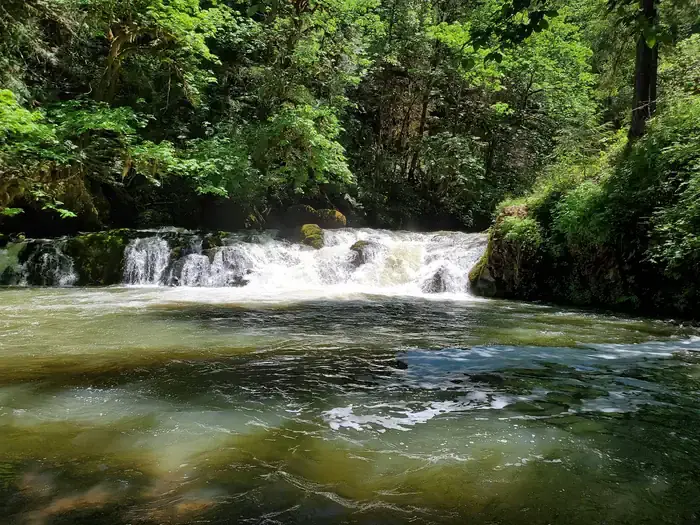
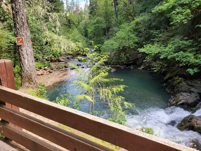
Cavitt Creek drops six feet over a ledge here and spreads into a pool at the foot of the fall. On a hot day the pool is what draws people. A stairway leads down to it from the campground. Fir, maple, and cedar close overhead, so most of the campsites and the swimming area lie in shade along the creek. The elevation is 1,050 feet, on the edge of the Umpqua National Forest. The Bureau of Land Management, which runs the site from its Roseburg District Office, calls it a favorite of locals. Travel Oregon places it away from the busier North Umpqua corridor.
Later in the year the fish take the falls. The BLM writes of leaping salmon in the fall months. Travel Oregon gives a longer run: salmon and steelhead leaping the falls from September through April. Trout season falls in summer. Cavitt Creek and Little River are open to trout fishing with artificial flies and lures only, from late May through mid-September. Dogs are not allowed in the swimming area.
Ten sites on three terraces
The way in leaves Highway 138 16.5 miles east of Roseburg and runs 6.7 miles south on Little River Road. It then turns west onto New Bridge Road, which becomes Cavitt Creek Road, and goes 3.2 miles more to the site. Vehicles longer than 34 feet are not permitted.
The campground stands on three terraced levels. Of its ten campsites, four make up a lower loop and six an upper. Four sites are on the water. There are no hookups. The day-use area has tables and a grill, and it is free. The site also has drinking water and vault restrooms. Firewood is not currently sold on site. Travel Oregon gives the season as May 20 to September 26.
Because of the terraces, the recreation.gov listing calls Cavitt Creek the Roseburg BLM’s least accessible recreation site. Renovations have improved wheelchair access to the parking areas, individual campsites, restrooms, and water spigots. The water play area cannot be reached by wheelchair, but the day-use area has an accessible spot for viewing the waterfall.
A few miles up Little River Road is the Wolf Creek Falls Trailhead. The trail runs 1.2 miles beside a stream through old-growth forest to a two-tier waterfall. There the water drops over rock cliffs 50 and 75 feet high into deep pools, and the flow varies through the year.
A bachelor on the creek
According to the Oregon State Library’s covered-bridge record, the country around the mouth of Cavitt Creek was settled in the early 1880s. It was named for Robert Cavitt, who settled on a tributary of Little River. Lewis A. McArthur’s Oregon Geographic Names, in its 1952 edition, gives him the middle initial L. McArthur says Cavitt was a bachelor who settled on the creek’s banks and lived alone there for many years. He was found dead in his cabin.
Frear’s bridge and a 2003 plan
A covered bridge crosses Little River where Cavitt Creek comes in, at the junction of Little River Road and Cavitt Creek Road, about seven miles south of Highway 138. The state record calls its builder, Floyd Frear, a noted Douglas County builder. He put it up in 1943 as a Howe truss 70 feet long. Its Tudor-arch portals were shaped to clear heavy log trucks, and raw logs serve as its upper and lower chords. Each side has three windows. Long narrow slits above each truss let in daylight and air. The roof is metal, the floor planks run lengthwise, and the structure sits on concrete piers. In 1979 the bridge was included in the thematic nomination of Oregon’s covered bridges to the National Register. It was not listed, at the request of the County.
On February 27, 2003, the BLM’s Swiftwater Field Office dated an environmental assessment covering sixteen recreation sites and trails, 365 acres in all. Cavitt Creek Falls Campground accounted for 16 of those acres. Ron Murphy led the project and Jim Luse prepared the document. Until then, each repair or upgrade had needed its own analysis. The assessment let the office respond quickly to damage from flood, wind, landslide, fire, or vandalism, and also covered routine upkeep and improvements. Nearly all the sites, Cavitt Creek among them, lay within the Riparian Reserve along the streams. The plan addressed hazard trees too. Trees that failed the minimum safe shell thickness would be felled and left on the forest floor, used as barrier logs, or placed in or along streams as structure. Those too small for any of that could become firewood for the campground.
Notable Events
- 2003Cavitt Creek Falls Campground was included among the sites encompassed by the Swiftwater recreation analysis. scholarsbank.uoregon.edu
People
- Robert Cavitt, Settler on a tributary of Little River and namesake of the Cavitt area (early 1880's).
- Robert L. Cavitt, Bachelor settler on the creek's banks and its namesake; lived alone for many years and was found dead in his cabin.
- Dan Dammann, Hydrology and soils preparer for the Swiftwater recreation assessment encompassing Cavitt Creek Falls.
- Francis Eatherington, Umpqua Watersheds, Inc. representative who commented on the Swiftwater recreation proposal encompassing Cavitt Creek Falls.
- Isaac Barner, Cultural resources preparer for the Swiftwater recreation assessment encompassing Cavitt Creek Falls.
- Jim Luse, EA coordinator and preparer for the Swiftwater recreation assessment encompassing Cavitt Creek Falls.
- Mike Crawford, Fisheries and wildlife preparer for the Swiftwater recreation assessment encompassing Cavitt Creek Falls.
- Ron Murphy, Recreation and visual resource management specialist and team lead for the Swiftwater assessment encompassing Cavitt Creek Falls.
- Ron Wickline, Botany preparer for the Swiftwater recreation assessment encompassing Cavitt Creek Falls.