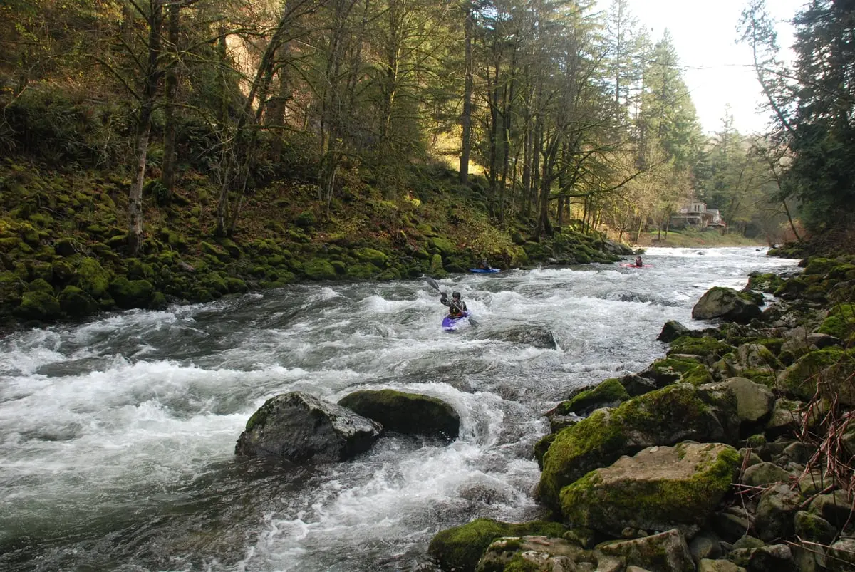
Big Eddy, Washougal River
Washougal, Clark County, Washington. Park.
Details

- Where
- Washougal, Clark County, WA. No street address stated. Directions
- Getting there
- Northeast Washougal River Road; limited parking along the shoulder.
- Access
- The Washougal River is non-motorized. Swim at your own risk. No lifeguards are present at any swimming location in Washougal along either the Columbia River or the Washougal River.
- Website
- visitwashougal.com
On warm days, cars line the shoulder of Northeast Washougal River Road above Big Eddy. The parking is limited, and the road is the only way in. Below it lies a large rocky beach, and beside the beach is a deep pool in the river’s eddy, just upriver from a small waterfall. Visit Washougal recommends it for swimming and sunbathing, and advises visitors to bring chairs and blankets, because the rocks are the only seating. The river carries no motorboats. No lifeguard works at Big Eddy or at any other swimming place in Washougal, on either the Washougal or the Columbia. The Washougal Arts and Culture Alliance names Big Eddy with the Sandy Swimming Hole, Dougan Falls, and Naked Falls as places where swimmers gather in warm weather.
Clark County’s page for the Washougal River neighborhood lists a single park, Big Eddy. The neighborhood association is inactive, and its offices of president, bylaws, and newsletter are all marked “none.”
The boulder garden in winter
The same name belongs to a rapid. American Whitewater describes a 7.1-mile reach of class III and IV water, which it calls the Big Eddy Section, that runs during the winter rains. Big Eddy comes about 2.61 miles below the put-in. It is a class IV boulder garden and the biggest drop on the run. Paddlers can scout it easily from the road, but the description warns that “when scouting from above the gradient is not visible.”
Local boaters use the lower Washougal as a rainy-season training run, and they progress by mileposts. Beginners launch at Milepost 3, then move up to Milepost 5. The next step is Milepost 7, which still avoids Big Eddy, “a serious rapid, not for beginners.” Once paddlers can run it, they start taking out at Milepost 3.
The rapid changes with the water. Teresa Gryder ran the section on May 6, 2023, at a gauge reading of six feet, which Dee Brodigan had told her was Brodigan’s personal minimum. That day, Gryder wrote, Big Eddy “was starting to look manky,” and a tree blocked the main flow just below the biggest drop. Her party put in below it. “At 8 feet,” she added, “Big Eddy is a BIG rapid and the water is high throughout.”
Lovell’s 3.79 acres
The beach is public through a 1990 purchase. Clark County records it as Lovell (Big Eddy), parcel 141056000, 3.79 acres within the Washougal River Greenway Upper. The only name given for the original grantor is Lovell. The county’s acquisition table shows $31,704.35 in Conservation Futures funds and $31,704.34 from other sources. A draft inventory from 2023 lists Clark County as the owner. The money came from a property levy that the county adopted in October 1985 and applied at 6 1/4 cents per $1,000 of assessed value for 1986 through 1990. At a hearing on August 2, 1989, the county extended the levy indefinitely. The program was renamed Legacy Lands in 2006.
A valley cut to old rock
The valley is older than any of these records. The 2013 USGS geologic map of the Washougal quadrangle, by Russell C. Evarts, Jim E. O’Connor, and Terry L. Tolan, describes the Washougal River cutting a deep valley through hilly uplands. In the northern part of the map, that valley exposes Oligocene volcanic bedrock.
For millennia the river carried salmon, steelhead, and trout. Early in the 20th century, loggers used a series of dams to move logs downstream, and the work badly damaged the spawning beds. The Washougal Arts and Culture Alliance says the river has since recovered. In 2024 the Cowlitz Indian Tribe and Columbia Land Trust removed the only dam left anywhere in the Washougal watershed. Fish can now pass from the whole basin to the ocean and back without a barrier.
Notable Events
- 1990The acquisition-history table records Lovell (Big Eddy) in Washougal River Greenway Upper: parcel 141056000, 3.79 acres, with $31,704.35 in Conservation Futures funds and $31,704.34 in other funds. clark.wa.gov
- 2024The Cowlitz Indian Tribe and Columbia Land Trust removed the only remaining dam in the entire Washougal watershed. washougalarts.org
People
- Lovell, Listed initial grantor of the county's Big Eddy property (1990).