.jpg)
Big Cedar Ridge fossil plant area
Worland, Washakie County, Wyoming. Fossil Site.
Details

- Where
- Worland, Washakie County, WY. No street address stated. Directions
- Getting there
- From the Worland Field Office, travel east out of Worland on US Highway 16 for 17.5 miles, then turn south onto BLM Road 1411 (Blue Bank Road). Follow Blue Bank Road for 14.5 miles.
- Fees
- No Fee.
- Access
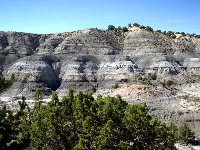
- The fossils are in the blue-gray ribbon of tuff across the middle of the ridge; visitors are asked to search only existing fossil pits and refrain from digging new exploratory holes.
- Phone
- 307-347-5100
- Website
- blm.gov
- Managed by
- Worland Field Office.
- Established
- Discovered in 1990 by paleobotanist Dr. Scott Wing of the Smithsonian Institution.
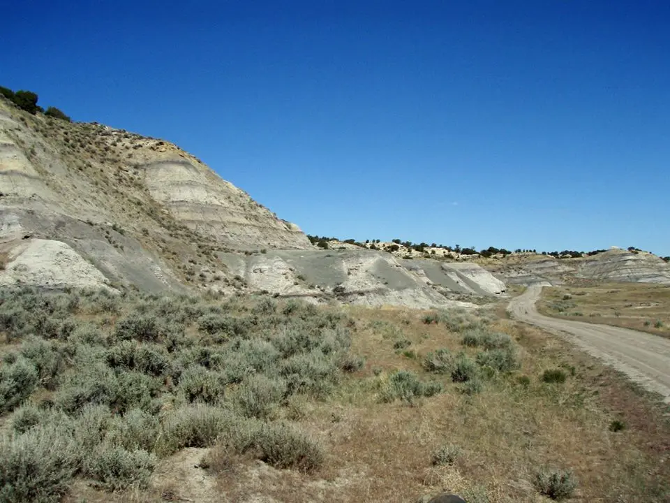
The parking area is on the west side of Blue Bank Road, BLM Road 1411, fourteen and a half miles south of where the road leaves U.S. Highway 16 east of Worland. Interpretive panels at its edge discuss the geology and illustrate the plants that came out of the slope beyond. That slope is Big Cedar Ridge, in Washakie County, and a ribbon of blue-gray rock runs across its middle. The Bureau of Land Management’s Worland Field Office manages the ground and charges no fee.
The ribbon is a tuff, a light, porous volcanic rock, and it holds the fossils. It lies within the Meeteetse Formation, a sequence of sandstones, shales, and claystones laid down on a lowland floodplain. The BLM’s Junior Ranger booklet for the site notes that the formation is found only in Wyoming and has yielded duck-billed dinosaurs at other sites. At Big Cedar Ridge it yields leaves.
Working the old pits
The plant fossils do not lie on the surface, and the booklet warns that not everyone who visits will find one. Visitors are asked to search only existing fossil pits and not to dig new exploratory holes. The booklet’s method is manual work. Open a small pit with a shovel and clear away the overburden. Cut horizontally and lift out blocks of the fossil-bearing rock, then split each block with a rock hammer along the line on its side. The rock tends to split where a fossil is. Leaves are the most common find. The booklet advises wrapping each keeper in several layers of toilet paper, which holds the rock together and lets it dry slowly. After two weeks the fossil is stable enough for a bookshelf. Its packing list adds a hat, water, sunscreen, gloves, sunglasses, masking tape, a notebook, a camera, and a magnifying glass to the shovel, hammer, and paper.
On BLM land, common plant and invertebrate fossils may be taken in reasonable amounts for personal use. A BLM Wyoming rockhounding leaflet defines that as a hobby collection or home display gathered with hand tools, and states that no fossil collected from public land may be sold, traded, or bartered. Bones, teeth, footprints, and archaeological artifacts may not be collected.
The ridge stands over 4,000 feet above sea level, in country the booklet calls arid to semi-arid, with less than 9 inches of rain a year and temperatures that range from below zero to well above 100 degrees. The BLM lists wildlife viewing and photography in the open Bighorn Basin among the activities at the site.
A fern marsh under ash
The sources give different ages. The Junior Ranger booklet places the flora at 73 million years ago. The BLM’s visitor page says seventy million. A 1997 Federal Register notice says about 72 million, and the Wyoming State Geological Survey in 1994 described the Meeteetse Formation as more than 72 million years old. All of them describe the same event: a mudflow of volcanic ash suddenly buried the whole landscape, and the plants were fossilized where they grew. The Federal Register notice called the result a complete late Cretaceous vegetative community of flowering plants, ferns, palms, and conifers that “preserves a true instant in time.” The notice added that it is possibly the oldest site in the world where plant, soil, and topographic associations can be seen.
At that time the Bighorn Basin lay close to sea level. It was wet and warm all year, averaging 75 degrees. The booklet explains one way that figure is reached. In warm climates most flowering plants have smooth-edged leaves, and in cooler ones most have toothed edges, so the share of smooth-margined species in a fossil sample indicates the average temperature.
The booklet, with reconstructions credited to the Smithsonian Institution, describes three plant communities. In the fern wetland, ferns of a species now found mostly in the tropics grew on peat soil, with scattered cycads and flowering plants related to buttercups. In the palmetto thicket, palms similar to some in the southern United States today grew on a slightly drier soil rich in organic matter. Along streams, where floods had recently disturbed the ground, flowering plants dominated. The most common of these had leaves similar to blackberry leaves, though the booklet says it is not yet known whether the fossil species was closely related to living blackberries.
The booklet counts about 175 plant species, many previously unknown and still being described. A later page of the same booklet gives “over 150.” The BLM’s visitor page reports more than 100 new species. Some of the leaves carry evidence of at least five different kinds of insects that fed on them.
Scott Wing’s ridge
The site was discovered in 1990 by Scott Wing, a paleobotanist at the Smithsonian Institution in Washington. A Smithsonian biography says Wing was born in New Orleans and learned the wonder of geology and fossils on a paleontological expedition to Wyoming at age 17. He joined the Smithsonian as Curator of Fossil Plants in 1984. According to the Federal Register notice, excavations at the ridge in 1992 identified more than 100 new plant species.
On 27 May 1993, Nature published a quantitative study of the flora by Wing, Leo J. Hickey of Yale University, and Carl C. Swisher of the Geochronology Center of the Institute of Human Origins in Berkeley. Because the plants were buried where they stood, the authors could measure how much ground each group covered. Dicotyledonous flowering plants made up 61 percent of the species but only 12 percent of the vegetational cover. Many of them appear to have been herbaceous, and they were abundant only in areas disturbed just before burial. Free-sporing plants made up 19 percent of the species and 49 percent of the cover. The only abundant and widespread flowering plant was a single species of palm, at about 25 percent of cover. The paper concluded that even in the mid-Maastrichtian, there were areas away from streams in the northern mid-latitudes where dicots had not yet become dominant.
Fourteen hundred acres on paper, and a fence
In May 1994, Wyoming Geo-notes, published by the Wyoming State Geological Survey, reported that the BLM intended to protect the fossil plants of the Big Cedar Ridge area, southwest of Tensleep. The area had been temporarily withdrawn for two years while the agency studied whether permanent withdrawal was feasible. Julie Coleman-Fike of the Worland BLM office explained that the fossils were so well preserved because a volcanic ash fall had buried them quickly. A 1995 environmental assessment, with public participation, covered about 1,550 acres of federal land and minerals around the discovery site. The fossil concentrations lay on about 260 of those acres.
On February 19, 1997, Alan R. Pierson, BLM State Director for Wyoming, signed the decision record, and the notice appeared in the Federal Register on March 3. It designated the 260 acres an Area of Critical Environmental Concern and committed the BLM to seek their withdrawal from the mining laws so that no mining claims could be staked there. The concentration areas were to be managed for research, public education, fossil interpretation, and noncommercial hobby collecting. Other surface-disturbing activity was prohibited. Later planning was to consider where trails, roads, exhibits, and facilities might go.
Wing kept returning to the Bighorn Basin. On July 9, 2011, during a field season spent on younger fossils of the Paleocene-Eocene Thermal Maximum, he spent most of a day guiding a group around Big Cedar Ridge. The trip was organized by the Wyoming Native Plant Society, the BLM, the Buffalo Bill Historical Center, and the Washakie Museum. “It was a delightful excursion with a group of really sharp and inquisitive folks,” he wrote for Smithsonian, “but it also ate up another day when we could have been collecting PETM fossils. The field season is always too short!”
In the summer of 2014, the BLM built the parking lot on Blue Bank Road and installed the interpretive panels, three of them developed with the Smithsonian. The final stage of that work was a buck and rail fence around the new lot.
Notable Events
- 1990Paleobotanist Dr. Scott Wing of the Smithsonian Institution discovered the site. blm.gov
- 1992Excavations in 1992 resulted in the identification of over 100 new plant species, and scientists have distinguished at least five different types of insect predation on the flora of Big Cedar Ridge. govinfo.gov
- 1993Scott L. Wing, Leo J. Hickey, and Carl C. Swisher published a quantitative study of the exceptional Late Cretaceous flora in Nature. nature.com
- 1994The area is temporarily withdrawn for two years while the feasibility of permanent withdrawal is evaluated by the BLM. web.archive.org
- 1995BLM conducted a public planning review of management issues arising from the discovery of the site's uniquely preserved fossil plants. digitalcommons.usu.edu
- 1997BLM's decision record and finding of no significant impact designated an Area of Critical Environmental Concern on 260 acres where fossil plants are concentrated, within the 1,550-acre Big Cedar Ridge Fossil Plant Area. govinfo.gov
- 1997The BLM said it would pursue withdrawal of the public lands from entry under the mining laws to prohibit staking mining claims on 260 acres. govinfo.gov
People
- Dr. Scott Wing, Paleobotanist at the Smithsonian Institution who discovered Big Cedar Ridge (1990).
- Alan R. Pierson, Bureau of Land Management Wyoming State Director who dated the decision record and finding of no significant impact for the management of Big Cedar Ridge Fossil Plant Area (February 19, 1997).
- Carl C. Swisher, Co-author of the Nature study of Big Cedar Ridge flora (1993).
- Leo J. Hickey, Co-author of the Nature study of Big Cedar Ridge flora (1993).
- Julie Coleman-Fike, Worland BLM office, who explained the Big Cedar Ridge fossil protection: the well preserved plant fossils resulted from quick burial by a volcanic ash fall (1994).
Sources
- blm.gov/visit/big-cedar-ridge
- blm.gov/sites/default/files/documents/files/BCR%20Jr%20Ranger_Web_0.pdf
- blm.gov/office/worland-field-office
- commons.wikimedia.org/wiki/File:Big_Cedar_Ridge_Fossil_Plant_Area_of_Critical_Environmental_Concern,_BLM_Wyoming_(15143941004).jpg
- blm.gov/sites/default/files/documents/files/WYNF-0004_rockhounding%20%28051418%29.pdf
- digitalcommons.usu.edu/wyoming_enviroassess/4
- smithsonianmag.com/science-nature/wyoming-paleontology-dispatch-5-an-all-star-team-of-scientists-43583394
- nature.com/articles/363342a0
.jpg)