Bear Creek Petrified Wood Site
Brothers, Crook County, Oregon. Recreational rockhounding area; Best time: May through October.
Details

- Where
- Brothers, Crook County, OR. No street address stated. Directions
- Getting there
- From Prineville, Highway 27 for 33 miles to Bear Creek Road; left 5.3 miles to a dirt road on the left; 0.1 miles to the fork, bear right 0.3 miles to a fence.
- Fees
- Day-use fees: none.
- Access
- The main collecting area is bordered by fenced private land to the east; open and close gates behind you; primitive camping allowed on public BLM land.
- Managed by
- Bureau of Land Management (BLM).
- Coordinates
- 43.940833, -120.6191.
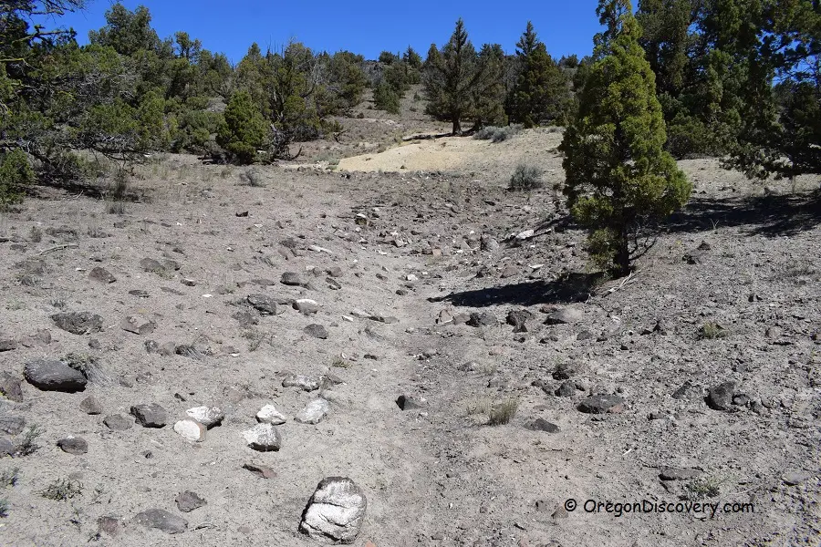
A wire fence crosses the dirt road a few tenths of a mile off Bear Creek Road, and it carries no sign. Past it, at a fork, rockhounding signs are posted. Half a mile to the right, the ground on the left side of the track opens into pits dug by earlier collectors looking for petrified wood. This is Site 1 of the Bear Creek collecting area, a Bureau of Land Management rockhounding ground in Crook County, Oregon. It lies 13 miles north of the small town of Brothers and 40 miles southeast of Prineville.
Oregon Discovery gives the way in. From Prineville, take Highway 27 for 33 miles to Bear Creek Road, 0.9 miles past Little Bear Creek Road. Turn east and go 5.3 miles to a dirt road on the left. Follow it 0.1 miles to a fork, then bear right 0.3 miles to the fence. The site sits between 4,000 and 4,250 feet. The same page calls for a high-clearance four-wheel-drive vehicle, warns that the road can be impassable in wet weather, and gives the best months as May through October.
The fence has turned at least one collector back. On July 8, 2021, a commenter signing as Jeff wrote on that page that he had driven from southern Oregon with the Central Oregon Rockhounding Map. He found closed wire fences on the way to both sites: “I didnt want to take a chance and go through a closed gate.” A reply the same day, signed Dennis, said the fence probably keeps cattle out and that there are no “No Trespass” signs. “Just make sure to close the fence/gate behind you.”
Pits at Site 1, a mile of road at Site 2
Site 1 covers 67 acres. It is the easier of the two collecting areas to reach and so the more popular. Fenced private land borders it on the east, and collecting stops at that line. Wood lies scattered across the surface, mostly of lower quality, though pieces show growth rings, cellular structure and bark. Oregon Discovery says the better specimens lie 2 to 5 feet down, in soil it calls relatively soft, and suggests working the edges or deeper layers of an existing hole. The BLM’s rock collecting guide for Oregon and Washington asks collectors to dig no deeper than four feet from the original ground surface and to fill in their holes.
Site 2 lies 2.5 miles up the left fork, on a long, bumpy road. Its 474 acres are all public land, stretched along a mile of road with ground to explore on every side. Fewer people make the drive, and by Oregon Discovery’s account the site often yields better material as a result. Primitive camping is allowed throughout the public BLM land. The nearest lodging is in Prineville or in Bend, 46 miles away.
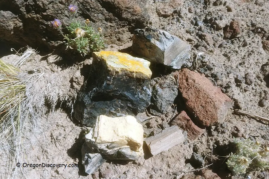
The wood runs black, brown, white, gray and yellow, and some agatized pieces show yellow and red. The Ochoco National Forest’s guide to local rocks says to identify petrified wood by the grain of its annual growth rings, which show most clearly when a piece is viewed from the end. Browns are the most common color in the region, the guide says, and the occasional agatized specimen takes an excellent polish. Oregon Discovery lists a shovel and a geology pick as the tools.
Collecting petrified wood on BLM land is free up to 25 pounds a day plus one piece, and no more than 250 pounds a year. A permit is needed beyond those limits, and two or more people may not pool their quotas to take pieces over 250 pounds. Ochoco National Forest geologist Carrie Gordon told The Bulletin in 2008 that rockhounds at sites including Bear Creek may use shovels and keep what they find. They may not use mechanized digging equipment or blast through the rock. “We’re talking about recreation, going out with the family for personal collection,” she said.
Trees under the Clarno ash
The wood began as trees about 50 million years ago. According to the Forest Service, a chain of volcanoes in eastern Oregon started erupting then, in a tropical climate that supported lush woodlands. Ash on the steep volcanic slopes mixed with tropical rains and swept across the land in large mudflows that buried plants and animals. The rocks from those volcanoes are called the Clarno Formation. The trees and wood debris entombed in them became much of the petrified wood collected in central Oregon today. Gordon dated the volcanic activity behind the region’s rocks to between 40 million and 50 million years ago. Later the Cascades rose high enough to block Pacific storms, and the country turned into the dry high desert it is now.
A map out of Prineville
Collectors find Bear Creek on the Central Oregon Rockhounding Map. The Bulletin reported that rockhounding areas here were first mapped in the 1960s, when local chambers of commerce maintained some of the sites. The original map appeared in 1964. Three partners have produced it ever since: the Ochoco National Forest, the Prineville District of the BLM and the Prineville-Crook County Chamber of Commerce. A 2004 edition added GPS coordinates, a briefing on the area’s geologic history and a “rockhound’s code of ethics.” The 2017 edition, printed on waterproof plastic and sold for $4, marks 11 collection areas.
In 2008 the chamber’s executive director, Brandi Hereford, said it gave out hundreds of the maps each year. “They’re very specific,” she said. “’I’m here to rockhound, where’s the map?’”
Notable Events
- 1960sCentral Oregon rockhounding areas were first mapped, with some sites maintained by local chambers of commerce. bendbulletin.com
- 1964The original Central Oregon Rockhounding Map was published, the start of the Ochoco National Forest, Prineville District Bureau of Land Management and Prineville-Crook County Chamber of Commerce collaboration that maps the public collection areas. madraspioneer.com
- 2004The 2004 version of the Central Oregon Rockhounding Map was produced by the Ochoco National Forest, the Prineville District Bureau of Land Management and the Prineville-Crook County Chamber of Commerce. bendbulletin.com
People
- Carrie Gordon, Ochoco National Forest geologist who explains how the area's rocks formed and states the collecting rules at sites including Bear Creek.